The main goal is to develop a holistic vulnerability assessment framework for coastal communities under wind-related natural hazards. For this purpose, we have already carried out a few studies from both the individual building perspective and the community perspective based on the performance-based structural analysis.
Following severe natural hazards, such as hurricanes, tornadoes, storm surges, or tsunamis, coastal communities could be devastated with immense damages to the infrastructure along with social and economic losses. With climate change projected to increase storm intensity and sea levels in the future, the resilience assessment of coastal communities is critical. For the prognosis of impacts and recovery, a community-level approach is needed considering the damages to individual infrastructures as well as the area as a whole. Starting from the individual building, performance-based structural analysis and assembly-based vulnerability assessment are required to include the loadings from multi-hazards. From the projected natural hazards, the community impacts, including damaged homes, power outages, disrupted road networks and bridges, economic losses, and social impacts could be simulated and predicted. The effects of mitigation strategies, such as elevation of coastline buildings, could then be evaluated to analyze their impacts on improving the community resilience to better inform cost-effective and optimal retrofits.
Related publications:
- Hughes, W., Zhang, W., Ding, Z., and Li, X. “Integrated Structural and Socioeconomic Resilience Assessment for Coastal Community Residential Building Hurricane Vulnerability.” Natural Hazards Review Natural Hazards Review, 23(3), https://doi.org/10.1061/(ASCE)NH.1527-6996.0000564.
- Ding, Z., Zhang, W., and Zhu, D. “Neural-Network Based Wind Pressure Prediction for Low-Rise Buildings with Genetic Algorithm and Bayesian Optimization.” Engineering Structures , Volume 260, 1 June 2022, 114203, https://doi.org/10.1016/j.engstruct.2022.114203..
- Ding, Z., Zhang, W., Hughes, W., and Zhu, D. “A modified sub-assembly approach for hurricane induced wind-surge-wave vulnerability assessment of low-rise wood buildings in coastal communities.” Journal of Wind Engineering and Industrial Aerodynamics, 218(2021) https://doi.org/10.1016/j.jweia.2021.104755.
- Ma, X., Zhang, W., Li, X., and Ding, Z. “Evaluating tsunami damage of wood residential buildings in a coastal community considering waterborne debris from buildings.” Engineering Structures, 244, 112761 https://doi.org/10.1016/j.engstruct.2021.112761.
The Fairfield Beach community, which is prone to extreme flooding from storm surges and was devastated by Hurricane Irene in 2011, is the benchmark of multiple studies. Following discussions with town engineers, three representative building models were developed based on the time-varying construction practices. The building damages are achieved from realistic structural analysis and the damages under different loadings are integrated using a modified sub-assembly method. The building damages are quantified from vulnerability curves or surfaces describing the ratio of damages to total elements on a specified sheathing as a function of the demand parameters, such as the coupled flooding depth and wind gusts.
The building damages are then linked to the larger community impacts. The long-term economic losses, morbidities, and home displacements could be probabilistically modeled. The effects of retrofit strategies such as elevation of buildings with high base flood elevations can be assessed. The optimal allocation of various mitigation measures under budgetary constraints and a defined storm scenario is then explored as in Figure 2.
Finally, the damages to other critical infrastructures in the community, including the power and water delivery systems and the transportation network, could be assessed to aid in projecting community recovery. The damages to trees could also be integrated. Figure 3 shows an example map of the probability of distribution pole failures along a given road and the subsequent probabilities the homes along those roads will lose power. Such maps can be developed to identify the most vulnerable infrastructures to aid decision-makers in their mitigation expenditures.
 (a)
(a)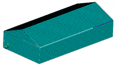 (b)
(b)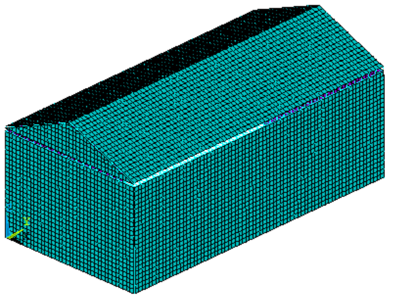 (c)
(c)
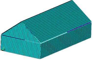
Figure 1. Representative building models (a) 1930s, (b) 1960s, (c) 1990s
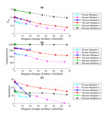
Figure 2. Effects of optimal mitigation allocation on the (a) structural damages, (b) home displacements, and (c) morbidities under defined storm scenarios with various budgetary constraints
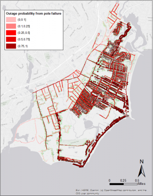
Figure 3. Map of overhead power distribution system pole failure probabilities along roadways under a 50 m/s gust and corresponding probability homes will lose power due to the failure